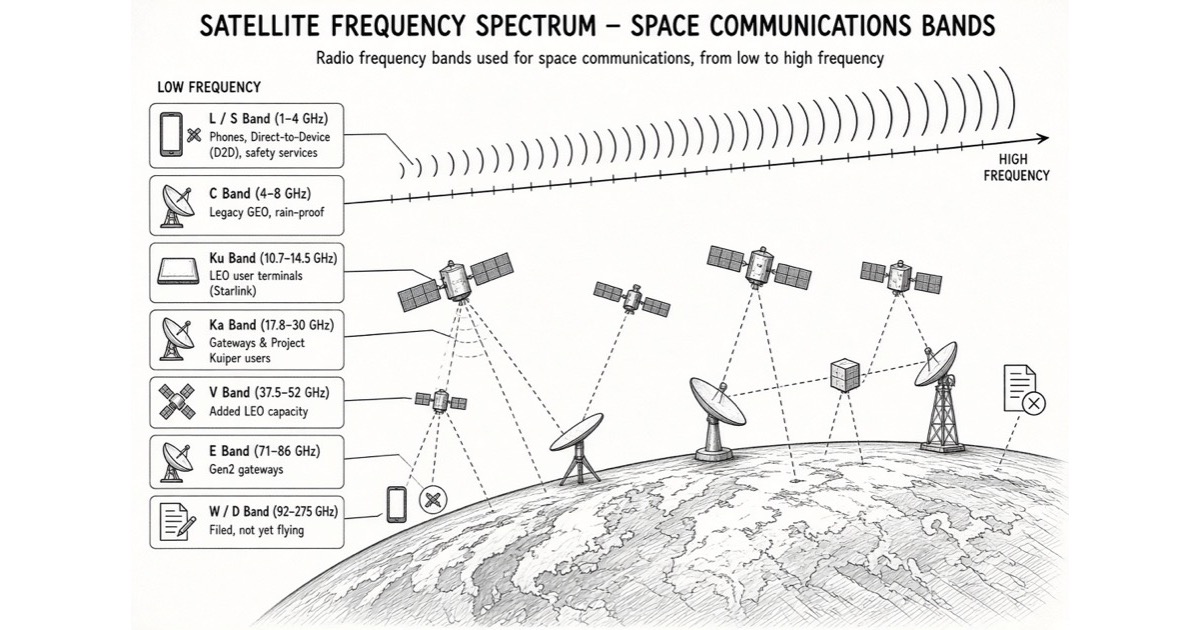
This is a guide to how radio spectrum works in space, written to be read from the top by someone who knows none of it. It covers what a frequency band is and what each one is used for, why a satellite's orbit decides which bands it can use at all, how the right to transmit on one is actually obtained and from whom, and who holds what today — ending on SpaceX ($SPCX) and the companies competing with it band by band.
It is organised around one formula, because a surprising share of the commercial and legal facts in this field fall straight out of it:
Free-space path loss, in decibels = 92.45 + 20·log10(distance in km) + 20·log10(frequency in GHz).
Put a Starlink shell altitude and a Starlink user frequency into it — 550 km, 12 GHz — and you get 168.8 dB. Move the identical link to geostationary orbit at 35,786 km and you get 205.1 dB. The difference is 36.3 dB, which because decibels are logarithmic means the geostationary receiver is getting about 1/4,200th of the power for the same transmitter.
That factor of 4,200 is the whole map. It is why low Earth orbit can afford frequencies that geostationary orbit cannot, why the high-capacity bands only became interesting once someone was willing to fly thousands of satellites, and why the constellations now converge on the same narrow slices of the radio spectrum and have to be refereed by a UN agency.
The five parts below work up from that: the bands and what they are for, the orbit physics that ties frequency to altitude, the two separate legal systems that decide who may transmit, what SpaceX holds, and who is fighting it for each band.
Part 1: The basics
Spectrum is a shared resource that has to be divided, not owned
Radio spectrum is the continuous range of electromagnetic frequencies usable for communication — from a few kHz to, in the ITU's formal table, 3,000 GHz. It is not consumed by use, but two transmitters on the same frequency in the same place at the same time interfere, and neither gets through. So the resource that has to be rationed is not the waves; it is non-interfering access.
The ITU Constitution states this directly: radio frequencies and satellite orbits are limited natural resources that must be used rationally, efficiently and economically, with equitable access for all countries. Everything downstream — the coordination queues, the priority dates, the interference limits — is machinery for that sentence.
Uplink and downlink are separate frequencies, always
Satellite links are two one-way paths, on different frequencies, because a satellite cannot easily receive a microwatt while transmitting a watt on the same channel.
- Downlink (space-to-Earth) — the satellite transmits, you receive.
- Uplink (Earth-to-space) — you transmit, the satellite receives.
Almost every band pairing you will see quoted is really a pair: Starlink users receive on roughly 10.7–12.7 GHz and transmit on roughly 14.0–14.5 GHz. Note that the uplink half is far narrower. That asymmetry is deliberate and it is why consumer satellite broadband has always been much faster down than up, and why the next generation of filings — aimed at devices that push data rather than pull it — asks for so much more uplink.
There are two completely different kinds of link in any constellation
This distinction is the one most coverage skips, and nothing makes sense without it.
- User links connect the satellite to the terminal in someone's garden, on a ship, or in a phone. There are millions of these, the antenna is small and cheap, and it may be moving, rained on, or badly pointed.
- Feeder or gateway links connect the satellite to a large ground station wired into the terrestrial internet. There are a few hundred of these, the antenna is large and expensive, professionally sited and pointed, and it can be built where it rarely rains.
Because the gateway end is engineered and the user end is not, operators put their hard bands on the gateway side. Starlink's users are on Ku. Its gateways are on Ka, E-band (71–76 GHz down, 81–86 GHz up) and increasingly V-band. That split is not a preference; it falls straight out of the path-loss formula.
- Optical inter-satellite links are the third leg and are not radio at all. Lasers between satellites carry traffic across the constellation so it can be dropped at a gateway far from the user. They need no spectrum licence, face no coordination queue, and are the main reason a mesh constellation can serve mid-ocean.
The letter bands, and a warning about them
The letter names (L, S, C, X, Ku, Ka, V, W) are Second World War radar conventions that stuck. Satellite people use them loosely — Starlink's "Ku" downlink starts at 10.7 GHz, which is formally IEEE X-band, and the "Ka" gateway downlink at 17.8 GHz is formally K-band. The illustration above and the table in the card at the top of this page both give the ranges as the industry actually uses them.
The trade-off along that table is monotonic and simple:
- Lower frequency — less path loss, penetrates rain, cloud, foliage and building walls, works with a nearly omnidirectional antenna. But there is very little of it, and it is already full. All of L- and S-band together is a couple of GHz wide.
- Higher frequency — enormous bandwidth (E-band alone offers two 5 GHz blocks, several times the total width of every mobile band in use), narrow steerable beams that let the same frequency be reused in the next town. But more path loss, severe rain fade, absorption by atmospheric oxygen and water vapour, and antennas that must be pointed precisely.
Bandwidth is capacity. That is why everybody wants to climb the table, and physics is what stops them.
Part 2: Why orbit decides which frequencies you can use
The three orbit classes
| Orbit | Typical altitude | Round-trip light time | Satellites for global coverage |
|---|---|---|---|
| LEO | 300–2,000 km | 3.7 ms at 550 km | Hundreds to thousands |
| MEO | ~8,000–20,000 km | 53 ms at 8,000 km | Tens |
| GEO | 35,786 km | 239 ms | Three, in principle |
Geostationary orbit is the special one: at exactly 35,786 km above the equator a satellite's orbital period matches Earth's rotation, so it hangs motionless in the sky. A fixed dish can be bolted to a wall and never moved again. That single property built the entire satellite television and legacy VSAT industry, and it costs 239 ms of round trip and 36.3 dB of link budget.
The four consequences of altitude
1. Path loss. Covered above: 36.3 dB from LEO to GEO at any given frequency. To close that gap a GEO system needs some combination of more transmit power, a bigger satellite antenna and a bigger dish on the ground. It can be done — GEO Ka-band systems exist — but each decibel is bought with mass, power or the customer's roof.
2. Latency. Light does 299,792 km per second and no engineering changes that. 550 km up and back is 3.7 ms; geostationary is 238.7 ms, a 65x difference, before adding the ground network at either end. That is the difference between a link that feels terrestrial and one where every interactive application notices.
3. Coverage footprint, and therefore satellite count. A satellite at 550 km, serving down to a 25° minimum elevation angle, sees about 2.76 million km² of Earth. A geostationary satellite on the same elevation constraint sees about 116.6 million km² — 42x more, roughly 23% of the planet's 510 million km² surface. Instantaneous global coverage from 550 km therefore needs at least about 185 satellites on pure geometry, and far more in practice because orbits are inclined, cross the poles unevenly and must maintain coverage as they move. Three GEO satellites cover everything but the high latitudes.
4. Motion, Doppler and handover. A 550 km satellite orbits at 7.59 km/s. Line-of-sight closing speed at that rate shifts a 12 GHz carrier by up to about ±304 kHz, and a 30 GHz carrier by up to about ±760 kHz — an upper bound, since only the radial component counts. A directly overhead pass above 25° elevation lasts about four and a half minutes, after which the terminal must hand over to another satellite. GEO has none of this: zero Doppler, zero handovers, point the dish once.
So LEO buys latency, link budget and capacity density, and pays for it with satellite count, constellation management, Doppler tracking and a phased-array terminal that has to electronically steer its beam several times an hour.
The synthesis: why the high bands live in LEO
Run the formula across the two variables together. A LEO Ka link at 176.8 dB is still 28 dB better off than a GEO Ku link at 205.1 dB. Being close buys you so much margin that you can spend it on frequency — and frequency is bandwidth, and bandwidth is capacity.
This is the entire reason V-, E- and W-band constellations are a 2020s phenomenon rather than a 1990s one. At GEO distances those bands are close to unusable for anything but short, engineered, fair-weather links. At 550 km, with a gateway antenna on a dry hilltop, E-band is a 5 GHz-wide firehose.
The counterweight is weather. Above roughly 10 GHz, rain attenuation climbs steeply with frequency, and above 50 GHz atmospheric absorption is severe in its own right. This is why the user link — the one on the roof of a house in a country the operator does not choose — stays on Ku, and the hard bands stay at the gateways, where you can build site diversity and simply route traffic to a gateway that is not currently in a storm. Adaptive coding and modulation, power control, beam steering, multi-satellite handoff and laser routing between satellites are all, in the end, ways of spending capacity to buy availability.
Part 3: How anyone actually gets the right to transmit
There are two legal regimes here and they are constantly conflated. One governs frequencies; the other governs being in space at all.
The ITU layer: frequencies and orbits
The International Telecommunication Union is a UN specialised agency, and its Radio Regulations are a binding treaty. Four things in it matter for this piece:
- Article 5, the Table of Frequency Allocations, divides the whole spectrum among services — Fixed-Satellite Service (FSS), Mobile-Satellite Service (MSS), Broadcasting-Satellite Service, space research, Earth exploration-satellite, radio astronomy and others. Allocations may be worldwide or differ across the three ITU Regions (1: Europe, Africa, Middle East and northern Asia; 2: the Americas; 3: Asia-Pacific).
- Within a band, a service is primary or secondary. Secondary must not interfere with primary and may claim no protection from it. That single ranking decides an enormous number of commercial questions.
- Articles 9 and 11 set the procedure: an operator files through its own national administration (the FCC for a US company), publishes advance information, then coordinates with every administration whose systems could be affected, then notifies. Success puts the assignment in the Master International Frequency Register, which is what confers international recognition and protection from harmful interference.
- Article 22 carries the EPFD limits — equivalent power flux density caps that non-geostationary systems must respect to protect geostationary networks. These limits were largely fixed around 2000, before adaptive mega-constellations existed, and updating them is one of the live fights heading into WRC-27.
The system is, in practice, first-come-first-served with an obligation to coordinate. Priority attaches to filing date. Later entrants must protect earlier ones. Milestone rules exist to stop "paper satellites" — filings made to hold a queue position with no intention to launch. A handful of bands, particularly planned broadcasting-satellite and some FSS allocations, instead use pre-assigned allotment plans so that countries which had no space industry in the 1970s still have something reserved.
World Radiocommunication Conferences every three to four years revise all of it.
The national layer, which people forget
An ITU filing is not permission to operate anywhere. Every country separately licenses landing rights, earth stations, gateway sites, terminal importation, lawful intercept and market access. Starlink's country-by-country rollout is a sequence of national regulatory decisions, not a single global authorisation, and the countries where the service is unavailable are unavailable for national policy reasons rather than technical ones.
Terrestrial mobile spectrum is more national still: an AWS-4 licence is a US property right with US buildout obligations, and it means nothing in Germany.
The space law layer: the Outer Space Treaty
Physical presence in orbit is governed by a different instrument — the 1967 Outer Space Treaty, plus the Rescue Agreement (1968), Liability Convention (1972), Registration Convention (1975) and the sparsely-ratified Moon Agreement (1979).
The provisions that bear on constellations:
- Non-appropriation. No state may claim sovereignty over outer space by use or occupation. Nobody owns an orbital shell. What a large constellation obtains is not title but coordination priority under the ITU and, physically, occupancy — which is precisely why the equitable-access argument is so persistent.
- Province of all mankind, and free use by all states without discrimination.
- State responsibility. States are internationally responsible for the activities of their non-governmental entities and must authorise and continuously supervise them. This is the hinge on which all national licensing hangs: the FCC's conditions on a Starlink authorisation are the United States discharging a treaty obligation.
- Liability for damage caused by space objects, elaborated in the 1972 Convention.
- Peaceful purposes — weapons of mass destruction may not be placed in orbit; the Moon and celestial bodies are for exclusively peaceful use. Conventional military activity in Earth orbit sits in a much greyer area, which is the legal space that systems like Starshield occupy.
Debris mitigation, collision avoidance and end-of-life disposal live mostly in soft law — the IADC and UN COPUOS guidelines, the 2019 long-term sustainability guidelines — made binding only when a national regulator writes them into a licence, which is increasingly what happens. There is no global space traffic management treaty. Conjunction warnings today are a patchwork of government catalogues, operator data sharing and bilateral arrangements.
The practical summary for an operator: ITU filing through your administration for the frequency and orbit; national licence for the space station and for every country you want to serve; launch licence from your own regulator; and continuing liability that stays with the launching and registering state for the life of the object.
Part 4: What SpaceX actually holds
SpaceX's position has two halves that are usually discussed as one. They are different assets with different economics.
Half one: the broadband constellation
- User links — Ku-band. Roughly 10.7–12.7 GHz down, 14.0–14.5 GHz up, channelised, serving the phased-array terminals. Chosen for rain performance, as Part 2 explains, and unlikely to move.
- Gateway links — Ka-band (roughly 17.8–20.2 GHz down, 27.5–30 GHz up), E-band (71–76 / 81–86 GHz, authorised for Gen2) and V-band segments (around 37.5–42.5 GHz down, 47–52 GHz up). Next-generation filings push further, into W-band and above.
- TT&C — telemetry, tracking and command — in portions of Ku and Ka, plus limited VHF beacons.
- Optical inter-satellite links, unlicensed, carrying the mesh.
Authorisations are layered and conditional: US space station authority and market access from the FCC, national landing rights everywhere else, ITU filings for priority. Many of the higher-band grants come with coordination requirements, EPFD conditions, radio astronomy coordination obligations and non-interference status where the use is non-conforming. A grant is a permission with strings, not a freehold.
Half two: exclusive terrestrial mobile spectrum
This is the change that makes SpaceX a different kind of company in spectrum terms. Early direct-to-cell service ran on a partner's spectrum — T-Mobile's PCS G-block, around 1910–1915 / 1990–1995 MHz — under supplemental coverage from space rules. Renting capacity from a carrier is a fundamentally weaker position than owning the licence.
The EchoStar transaction, reported at roughly $19.6B in cash and stock and cleared in 2026, moves about 65 MHz of US mid-band into SpaceX's own hands: AWS-4 (~40 MHz around 2000–2020 / 2180–2200 MHz), the H-block (~10 MHz at 1915–1920 / 1995–2000 MHz), and unpaired AWS-3 (~15 MHz in the 1695–1710 MHz range). It is technology-neutral and carries buildout conditions, which means it can be used from space, from towers, or both.
Three things follow, and they are worth separating from the headline price:
- Capacity. 65 MHz of exclusive mid-band is a different order of magnitude from a 5 MHz shared G-block. Texting becomes voice and data.
- Handset support. Owning standardised bands rather than borrowing a carrier's makes it a question of chipset and band-class support in ordinary phones rather than of one operator's goodwill.
- Optionality. A technology-neutral licence with buildout obligations permits a hybrid terrestrial-plus-satellite network. Whether SpaceX builds ground infrastructure is now a choice it owns.
Outside the US, direct-to-device remains a patchwork: national MSS licences, partner carriers' cellular spectrum, and ITU coordination, with some requests for protected MSS bands dismissed or trimmed to protect incumbents.
One caution about the constellation numbers. Next-generation filings ask for satellite counts and per-satellite capacities far beyond what is flying — figures in the tens of thousands of satellites, and terabit-class per-satellite downlinks. A filing is a request, subject to coordination, EPFD, national approval and the small matter of building the hardware. It is evidence of intent and of queue position. It is not a fleet.
Part 5: Who is competing, band by band
The competition splits along exactly the line Part 1 drew: broadband to a dish, versus data to a phone. Almost nobody is seriously in both.
Broadband — the fight is in Ku and Ka
| System | Positioning | Primary bands |
|---|---|---|
| Amazon Kuiper (AMZN) | Consumer and enterprise broadband; the closest pure commercial rival | Ka-band for users and gateways (~17.7–20.2 GHz down, 27.5–30 GHz up), expanding into V-band |
| Eutelsat OneWeb | Enterprise, government, mobility; first-generation constellation largely complete | Ku user links, Ka gateways |
| Telesat Lightspeed | Enterprise, government, backhaul; optical inter-satellite links | Ka primary, V-band planned |
| Chinese state constellations (Guowang, Qianfan) | Sovereign capacity and geopolitical reach | Ku/Ka, higher bands in filings |
Note what the right-hand column says: everyone is in the same two bands. Kuiper puts its users on Ka, where Starlink puts its gateways — a genuine architectural difference, trading rain margin for bandwidth at the customer end. The consequence is that NGSO-to-NGSO coordination, and the EPFD rules protecting the incumbent GEO operators underneath all of them, are not a regulatory footnote. They are a direct constraint on how much capacity each system can actually sell.
Starlink's structural advantages here are not spectral. They are launch cost, vertical integration and terminal manufacturing scale — plus the priority date on its filings.
Direct-to-device — the fight is in L-, S- and borrowed cellular bands
| System | Approach | Spectrum |
|---|---|---|
| AST SpaceMobile ($ASTS) | Very large phased arrays; carrier partnerships with AT&T and Verizon | Partner low-band cellular (700/800 MHz), plus L- and S-band MSS rights around 1980–2010 / 2170–2200 MHz |
| Lynk / Omnispace (merged) | Carrier partnerships plus own MSS holdings | Partner cellular plus S-band MSS |
| Globalstar | Powers Apple's satellite features; Amazon has moved to control it | L- and S-band MSS |
| Iridium | Mature voice, data and IoT; not chasing mass-market broadband | L-band |
| SpaceX Direct to Cell | Partner spectrum today, exclusive mid-band next | T-Mobile G-block now; AWS-4 / H-block / AWS-3 from EchoStar |
The distinguishing fact in this table is the third column of the last row. Every other D2D contender either rents capacity from carriers or holds narrow MSS allocations. SpaceX will hold 65 MHz of exclusive, technology-neutral, mid-band US spectrum outright. That is a licence position, not an engineering one, and it is the harder kind to replicate — you cannot launch your way to it.
Military: Starshield
Starshield is the national-security variant, and the honest summary is that its spectrum position is largely not public. What is on the record: large US government awards for a proliferated LEO data transport backbone, and NRO-related contracts for proliferated sensing satellites. It leverages the commercial Starlink band plan plus government assignments that are not published.
Under international law it sits inside the same Outer Space Treaty framework as everything else — no weapons of mass destruction in orbit, state responsibility, state liability — while conventional military use of Earth orbit remains legally grey. The dual-use point is the commercially interesting one: the same production line, launch cadence and mesh architecture serve both, so government revenue amortises infrastructure the commercial business needs anyway.
What to watch
- EPFD revision at WRC-27. The limits protecting GEO from NGSO were set for a world of a few dozen satellites. Whether they are loosened, tightened or left alone sets a hard ceiling on how much capacity every LEO broadband system can sell in Ku and Ka. This is the single largest regulatory variable in the sector.
- Buildout conditions on the EchoStar licences. Technology-neutral flexible-use spectrum comes with deadlines. Watch whether SpaceX satisfies them from orbit or starts buying terrestrial sites — the answer tells you which business it thinks it bought.
- Handset band support. Exclusive spectrum is worth what the installed base of phones can receive. Chipset and band-class adoption is the gating item on direct-to-cell revenue, and it moves on handset refresh cycles, not on launch cadence.
- Kuiper's Ka-band user link in the rain. Kuiper's architectural bet differs from Starlink's at the customer end. Real-world availability figures in wet climates are the test, and they will show up in churn before they show up in a filing.
- Whether next-generation filings convert. Filings ask for tens of thousands of satellites in bands that have never carried consumer traffic. The gap between a coordination request and flying hardware is where most satellite-industry forecasting has gone wrong for forty years.
The path-loss, latency, footprint, orbital-velocity, Doppler and pass-duration figures in this piece and in the charts above are R40 arithmetic from published constants, and every one is reproducible: free-space path loss from 92.45 + 20·log10(d km) + 20·log10(f GHz); light time from 299,792 km/s; orbital velocity from sqrt(398,600 / r) with r in km from Earth's centre; footprint from the spherical-cap area 2πRe²(1 − cos λ) with Re = 6,371 km, a 25° minimum elevation angle and Earth's surface taken as 510 million km². The 25° elevation constraint is our assumption, not an operator disclosure, and footprint and satellite-count figures move materially if you change it; the ~185-satellite figure is a geometric floor for instantaneous coverage and not a constellation design. Band edges are the ranges in common industry use and are rounded — real authorisations are channelised, split by ITU Region, and subdivided by service. The ITU material — the Table of Frequency Allocations in Article 5, primary and secondary status, the coordination procedure in Articles 9 and 11, the Master International Frequency Register, and the EPFD limits in Article 22 — is from the Radio Regulations; the space-law material is from the 1967 Outer Space Treaty and the associated conventions. The company-specific claims — SpaceX's band holdings and gateway authorisations, the ~$19.6B EchoStar consideration and the ~65 MHz of AWS-4, H-block and unpaired AWS-3 it conveys, the T-Mobile G-block arrangement, competitors' band assignments and Starshield's government awards — come from FCC orders, filings and public reporting rather than from any dataset this site stores, and are stated as of August 2026; they are the most perishable figures here, because processing rounds, grants and deals change them continuously. For any specific band or country, the primary sources are the FCC's ICFS/IBFS filing systems and the relevant national regulator. This piece contains no forecast and no valuation; where it describes an advantage, it describes a licence or a physical constraint, not an expected return.